


st juery

tosan
User
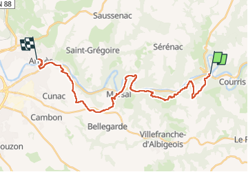

Length
29 km

Max alt
432 m

Uphill gradient
870 m
Km-Effort
41 km

Min alt
156 m

Downhill gradient
910 m
Boucle
No
Creation date :
2024-06-08 04:05:40.443
Updated on :
2024-06-08 15:25:06.482
10h49
Difficulty : Very difficult

FREE GPS app for hiking
 SityTrail
IGN / Geographical institutes
SityTrail Plus
The world is yours!
About
Trail Walking of 29 km to be discovered at Occitania, Tarn, Ambialet. This trail is proposed by tosan.
Positioning
Country:
France
Region :
Occitania
Department/Province :
Tarn
Municipality :
Ambialet
Location:
Unknown
Start:(Dec)
Start:(UTM)
450010 ; 4865883 (31T) N.
Comments