


Paris Prague

jcm17
User
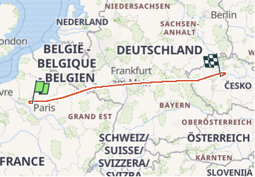

Length
943 km

Max alt
770 m

Uphill gradient
23160 m
Km-Effort
1251 km

Min alt
48 m

Downhill gradient
22910 m
Boucle
No
Creation date :
2024-06-07 10:50:09.896
Updated on :
2024-06-08 21:06:44.913
1h27
Difficulty : Very easy

FREE GPS app for hiking
 SityTrail
IGN / Geographical institutes
SityTrail Plus
The world is yours!
About
Trail Plane of 943 km to be discovered at Ile-de-France, Seine-et-Marne, Mauregard. This trail is proposed by jcm17.
Positioning
Country:
France
Region :
Ile-de-France
Department/Province :
Seine-et-Marne
Municipality :
Mauregard
Location:
Unknown
Start:(Dec)
Start:(UTM)
467205 ; 5428928 (31U) N.
Comments