


Aix les boulevards

MAUVAGE Patrick
User
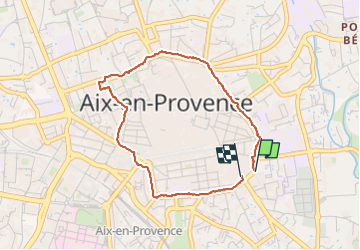

Length
3.7 km

Max alt
216 m

Uphill gradient
42 m
Km-Effort
4.2 km

Min alt
185 m

Downhill gradient
45 m
Boucle
Yes
Creation date :
2024-06-09 08:01:46.0
Updated on :
2024-06-11 18:33:15.328
57m
Difficulty : Easy

FREE GPS app for hiking
 SityTrail
IGN / Geographical institutes
SityTrail Plus
The world is yours!
About
Trail Walking of 3.7 km to be discovered at Provence-Alpes-Côte d'Azur, Bouches-du-Rhône, Aix-en-Provence. This trail is proposed by MAUVAGE Patrick.
Photos

Positioning
Country:
France
Region :
Provence-Alpes-Côte d'Azur
Department/Province :
Bouches-du-Rhône
Municipality :
Aix-en-Provence
Location:
Unknown
Start:(Dec)
Start:(UTM)
698401 ; 4822105 (31T) N.
Comments