


les balcons de la Roanne

ajd26
User

Length
17.9 km

Max alt
1178 m

Uphill gradient
924 m
Km-Effort
30 km

Min alt
347 m

Downhill gradient
925 m
Boucle
Yes
Creation date :
2019-05-19 18:05:07.851
Updated on :
2019-05-19 18:05:09.25
5h15
Difficulty : Medium

FREE GPS app for hiking
 SityTrail
IGN / Geographical institutes
SityTrail Plus
The world is yours!
About
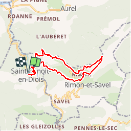
Trail Walking of 17.9 km to be discovered at Auvergne-Rhône-Alpes, Drôme, Saint-Benoit-en-Diois. This trail is proposed by ajd26.
Description
départ de St Benoit en Diois
Positioning
Country:
France
Region :
Auvergne-Rhône-Alpes
Department/Province :
Drôme
Municipality :
Saint-Benoit-en-Diois
Location:
Unknown
Start:(Dec)
Start:(UTM)
680109 ; 4948099 (31T) N.
Comments