


69 decines grand large

trietsch
User
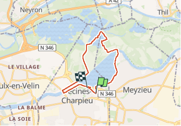

Length
12.8 km

Max alt
198 m

Uphill gradient
88 m
Km-Effort
13.9 km

Min alt
170 m

Downhill gradient
81 m
Boucle
No
Creation date :
2024-06-09 07:19:23.0
Updated on :
2024-06-09 12:29:20.271
3h09
Difficulty : Difficult

FREE GPS app for hiking
 SityTrail
IGN / Geographical institutes
SityTrail Plus
The world is yours!
About
Trail Walking of 12.8 km to be discovered at Auvergne-Rhône-Alpes, Métropole de Lyon, Décines-Charpieu. This trail is proposed by trietsch.
Description
départ arrêt tram T3 Décines grand larges
Positioning
Country:
France
Region :
Auvergne-Rhône-Alpes
Department/Province :
Métropole de Lyon
Municipality :
Décines-Charpieu
Location:
Unknown
Start:(Dec)
Start:(UTM)
653615 ; 5070918 (31T) N.
Comments