Le môle

Michel_Martin
User
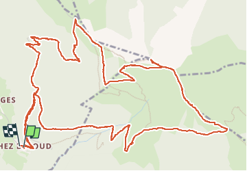

Length
9.6 km

Max alt
1842 m

Uphill gradient
701 m
Km-Effort
19 km

Min alt
1163 m

Downhill gradient
709 m
Boucle
Yes
Creation date :
2024-06-04 06:58:53.104
Updated on :
2024-06-09 13:17:50.24
3h31
Difficulty : Easy

FREE GPS app for hiking
 SityTrail
IGN / Geographical institutes
SityTrail Plus
The world is yours!
About
Trail Walking of 9.6 km to be discovered at Auvergne-Rhône-Alpes, Upper Savoy, Saint-Jean-de-Tholome. This trail is proposed by Michel_Martin.
Positioning
Country:
France
Region :
Auvergne-Rhône-Alpes
Department/Province :
Upper Savoy
Municipality :
Saint-Jean-de-Tholome
Location:
Unknown
Start:(Dec)
Start:(UTM)
302032 ; 5108241 (32T) N.
Comments