


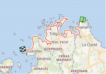
PLOUMANAC'H - LANDRELLEC

gallo
User

Length
15.4 km

Max alt
24 m

Uphill gradient
138 m
Km-Effort
17.3 km

Min alt
-1 m

Downhill gradient
140 m
Boucle
No
Creation date :
2024-06-10 06:52:04.319
Updated on :
2024-06-10 07:03:20.554
3h55
Difficulty : Difficult

FREE GPS app for hiking
 SityTrail
IGN / Geographical institutes
SityTrail Plus
The world is yours!
About
Trail Walking of 15.4 km to be discovered at Brittany, Côtes-d'Armor, Perros-Guirec. This trail is proposed by gallo.
Positioning
Country:
France
Region :
Brittany
Department/Province :
Côtes-d'Armor
Municipality :
Perros-Guirec
Location:
Unknown
Start:(Dec)
Start:(UTM)
464307 ; 5408929 (30U) N.
Comments