


trehorenteuc folle pensee

Yolande Olivier
User
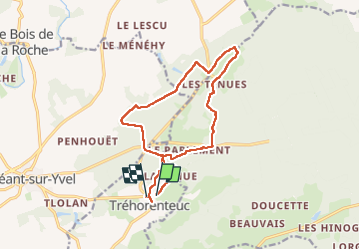

Length
13.6 km

Max alt
197 m

Uphill gradient
194 m
Km-Effort
16.2 km

Min alt
90 m

Downhill gradient
195 m
Boucle
No
Creation date :
2024-06-10 11:13:48.368
Updated on :
2024-06-10 14:07:20.105
2h52
Difficulty : Difficult

FREE GPS app for hiking
 SityTrail
IGN / Geographical institutes
SityTrail Plus
The world is yours!
About
Trail Walking of 13.6 km to be discovered at Brittany, Morbihan, Tréhorenteuc. This trail is proposed by Yolande Olivier.
Description
FP
Positioning
Country:
France
Region :
Brittany
Department/Province :
Morbihan
Municipality :
Tréhorenteuc
Location:
Unknown
Start:(Dec)
Start:(UTM)
553327 ; 5317541 (30U) N.
Comments