


vers HT Garonne Foix la bastide Seoute

taguette
User
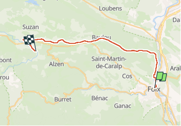

Length
23 km

Max alt
523 m

Uphill gradient
340 m
Km-Effort
28 km

Min alt
376 m

Downhill gradient
307 m
Boucle
No
Creation date :
2024-06-10 06:35:08.998
Updated on :
2024-06-10 15:02:29.937
6h29
Difficulty : Very difficult

FREE GPS app for hiking
 SityTrail
IGN / Geographical institutes
SityTrail Plus
The world is yours!
About
Trail Walking of 23 km to be discovered at Occitania, Ariège, Foix. This trail is proposed by taguette.
Positioning
Country:
France
Region :
Occitania
Department/Province :
Ariège
Municipality :
Foix
Location:
Unknown
Start:(Dec)
Start:(UTM)
386349 ; 4757909 (31T) N.
Comments