


Aspiran claudine

Evelyne3
User
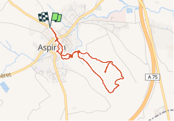

Length
4.5 km

Max alt
104 m

Uphill gradient
106 m
Km-Effort
5.9 km

Min alt
49 m

Downhill gradient
106 m
Boucle
Yes
Creation date :
2024-06-10 11:51:34.745
Updated on :
2024-06-10 15:05:34.419
3h13
Difficulty : Easy

FREE GPS app for hiking
 SityTrail
IGN / Geographical institutes
SityTrail Plus
The world is yours!
About
Trail Walking of 4.5 km to be discovered at Occitania, Hérault, Aspiran. This trail is proposed by Evelyne3.
Description
crapahut en sous bois
Positioning
Country:
France
Region :
Occitania
Department/Province :
Hérault
Municipality :
Aspiran
Location:
Unknown
Start:(Dec)
Start:(UTM)
536184 ; 4824031 (31T) N.
Comments