


la corne et retour

yvesconnes
User
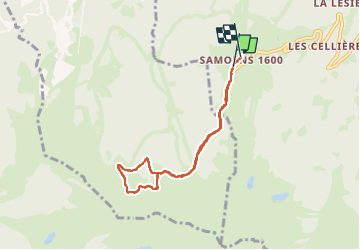

Length
6.5 km

Max alt
1708 m

Uphill gradient
312 m
Km-Effort
10.6 km

Min alt
1548 m

Downhill gradient
308 m
Boucle
Yes
Creation date :
2024-06-10 12:55:55.845
Updated on :
2024-06-10 15:20:18.807
2h23
Difficulty : Medium

FREE GPS app for hiking
 SityTrail
IGN / Geographical institutes
SityTrail Plus
The world is yours!
About
Trail Walking of 6.5 km to be discovered at Auvergne-Rhône-Alpes, Upper Savoy, Samoëns. This trail is proposed by yvesconnes.
Positioning
Country:
France
Region :
Auvergne-Rhône-Alpes
Department/Province :
Upper Savoy
Municipality :
Samoëns
Location:
Unknown
Start:(Dec)
Start:(UTM)
321835 ; 5102453 (32T) N.
Comments