


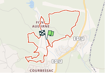
MARGUERITTES FONT D'AUBARNE

rando30129
User

Length
6.5 km

Max alt
150 m

Uphill gradient
130 m
Km-Effort
8.2 km

Min alt
91 m

Downhill gradient
131 m
Boucle
Yes
Creation date :
2024-06-11 06:30:28.307
Updated on :
2024-06-16 11:49:36.1
2h30
Difficulty : Medium

FREE GPS app for hiking
 SityTrail
IGN / Geographical institutes
SityTrail Plus
The world is yours!
About
Trail Walking of 6.5 km to be discovered at Occitania, Gard, Nimes. This trail is proposed by rando30129.
Photos


Positioning
Country:
France
Region :
Occitania
Department/Province :
Gard
Municipality :
Nimes
Location:
Unknown
Start:(Dec)
Start:(UTM)
612942 ; 4859036 (31T) N.
Comments