


Pont du Roi

Bonnefois Bernard
User
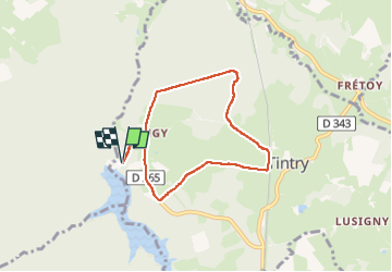

Length
6.4 km

Max alt
472 m

Uphill gradient
70 m
Km-Effort
7.4 km

Min alt
433 m

Downhill gradient
70 m
Boucle
Yes
Creation date :
2024-06-11 06:53:31.0
Updated on :
2024-06-11 09:05:55.533

FREE GPS app for hiking
 SityTrail
IGN / Geographical institutes
SityTrail Plus
The world is yours!
About
Trail of 6.4 km to be discovered at Bourgogne-Franche-Comté, Saône-et-Loire, Tintry. This trail is proposed by Bonnefois Bernard.
Positioning
Country:
France
Region :
Bourgogne-Franche-Comté
Department/Province :
Saône-et-Loire
Municipality :
Tintry
Location:
Unknown
Start:(Dec)
Start:(UTM)
611800 ; 5198471 (31T) N.
Comments