


De poligny a souppes A/R.

Isidore Hernandez 2
User
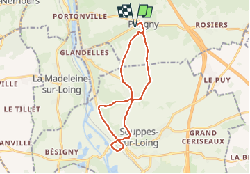

Length
13.5 km

Max alt
128 m

Uphill gradient
153 m
Km-Effort
15.6 km

Min alt
63 m

Downhill gradient
153 m
Boucle
Yes
Creation date :
2024-06-11 06:51:53.025
Updated on :
2024-06-11 09:32:49.695
2h37
Difficulty : Easy

FREE GPS app for hiking
 SityTrail
IGN / Geographical institutes
SityTrail Plus
The world is yours!
About
Trail Walking of 13.5 km to be discovered at Ile-de-France, Seine-et-Marne, Poligny. This trail is proposed by Isidore Hernandez 2.
Positioning
Country:
France
Region :
Ile-de-France
Department/Province :
Seine-et-Marne
Municipality :
Poligny
Location:
Unknown
Start:(Dec)
Start:(UTM)
480758 ; 5341158 (31U) N.
Comments