


TARBES jardin massey RS 2024

LouisROGER
User GUIDE
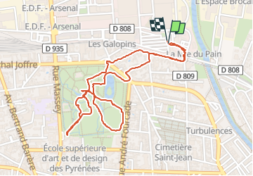

Length
2.9 km

Max alt
316 m

Uphill gradient
20 m
Km-Effort
3.2 km

Min alt
305 m

Downhill gradient
20 m
Boucle
Yes
Creation date :
2024-06-11 11:59:15.836
Updated on :
2024-06-22 18:31:45.31
43m
Difficulty : Easy

FREE GPS app for hiking
 SityTrail
IGN / Geographical institutes
SityTrail Plus
The world is yours!
About
Trail Walking of 2.9 km to be discovered at Occitania, Hautespyrenees, Tarbes. This trail is proposed by LouisROGER.
Positioning
Country:
France
Region :
Occitania
Department/Province :
Hautespyrenees
Municipality :
Tarbes
Location:
Unknown
Start:(Dec)
Start:(UTM)
262977 ; 4791660 (31T) N.
Comments