


Montrichard1

jcpinon
User
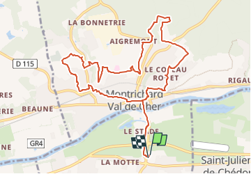

Length
11.7 km

Max alt
139 m

Uphill gradient
248 m
Km-Effort
15 km

Min alt
57 m

Downhill gradient
249 m
Boucle
Yes
Creation date :
2024-06-11 17:55:16.318
Updated on :
2024-06-11 17:55:57.748
3h24
Difficulty : Easy

FREE GPS app for hiking
 SityTrail
IGN / Geographical institutes
SityTrail Plus
The world is yours!
About
Trail On foot of 11.7 km to be discovered at Centre-Loire Valley, Loir-et-Cher, Faverolles-sur-Cher. This trail is proposed by jcpinon.
Positioning
Country:
France
Region :
Centre-Loire Valley
Department/Province :
Loir-et-Cher
Municipality :
Faverolles-sur-Cher
Location:
Unknown
Start:(Dec)
Start:(UTM)
363125 ; 5243864 (31T) N.
Comments