


J1 etape depart de Savines le lac

CASSISFRAMBOISE
User
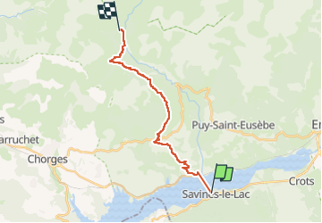

Length
18.1 km

Max alt
1789 m

Uphill gradient
1154 m
Km-Effort
31 km

Min alt
757 m

Downhill gradient
446 m
Boucle
No
Creation date :
2024-06-12 12:03:24.818
Updated on :
2024-06-12 12:04:12.067
7h04
Difficulty : Very difficult

FREE GPS app for hiking
 SityTrail
IGN / Geographical institutes
SityTrail Plus
The world is yours!
About
Trail Walking of 18.1 km to be discovered at Provence-Alpes-Côte d'Azur, Hautes-Alpes, Savines-le-Lac. This trail is proposed by CASSISFRAMBOISE.
Positioning
Country:
France
Region :
Provence-Alpes-Côte d'Azur
Department/Province :
Hautes-Alpes
Municipality :
Savines-le-Lac
Location:
Unknown
Start:(Dec)
Start:(UTM)
293511 ; 4933610 (32T) N.
Comments