


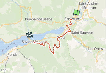
J3 depart Embrun

CASSISFRAMBOISE
User

Length
21 km

Max alt
1180 m

Uphill gradient
656 m
Km-Effort
30 km

Min alt
782 m

Downhill gradient
712 m
Boucle
No
Creation date :
2024-06-12 12:19:05.6
Updated on :
2024-06-12 12:19:24.846
6h47
Difficulty : Very difficult

FREE GPS app for hiking
 SityTrail
IGN / Geographical institutes
SityTrail Plus
The world is yours!
About
Trail Walking of 21 km to be discovered at Provence-Alpes-Côte d'Azur, Hautes-Alpes, Embrun. This trail is proposed by CASSISFRAMBOISE.
Positioning
Country:
France
Region :
Provence-Alpes-Côte d'Azur
Department/Province :
Hautes-Alpes
Municipality :
Embrun
Location:
Unknown
Start:(Dec)
Start:(UTM)
301252 ; 4937493 (32T) N.
Comments