


Montauroux - St Cezaire

GeorgesV.
User
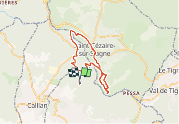

Length
16.3 km

Max alt
485 m

Uphill gradient
802 m
Km-Effort
27 km

Min alt
169 m

Downhill gradient
807 m
Boucle
Yes
Creation date :
2024-06-12 05:55:40.0
Updated on :
2024-06-12 13:21:49.341

FREE GPS app for hiking
 SityTrail
IGN / Geographical institutes
SityTrail Plus
The world is yours!
About
Trail of 16.3 km to be discovered at Provence-Alpes-Côte d'Azur, Var, Montauroux. This trail is proposed by GeorgesV..
Positioning
Country:
France
Region :
Provence-Alpes-Côte d'Azur
Department/Province :
Var
Municipality :
Montauroux
Location:
Unknown
Start:(Dec)
Start:(UTM)
321088 ; 4833543 (32T) N.
Comments