


Foix Bagnères de Luchon etap2 moulis

taguette
User
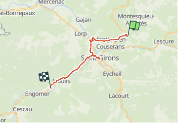

Length
20 km

Max alt
477 m

Uphill gradient
287 m
Km-Effort
24 km

Min alt
382 m

Downhill gradient
280 m
Boucle
No
Creation date :
2024-06-12 06:42:59.432
Updated on :
2024-06-12 13:36:59.994
6h53
Difficulty : Very difficult

FREE GPS app for hiking
 SityTrail
IGN / Geographical institutes
SityTrail Plus
The world is yours!
About
Trail Walking of 20 km to be discovered at Occitania, Ariège, Montjoie-en-Couserans. This trail is proposed by taguette.
Positioning
Country:
France
Region :
Occitania
Department/Province :
Ariège
Municipality :
Montjoie-en-Couserans
Location:
Unknown
Start:(Dec)
Start:(UTM)
352105 ; 4763025 (31T) N.
Comments