


Les Passerelles Himalayennes

chasle
User
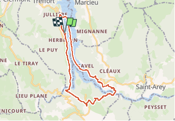

Length
18.7 km

Max alt
692 m

Uphill gradient
528 m
Km-Effort
26 km

Min alt
468 m

Downhill gradient
532 m
Boucle
Yes
Creation date :
2024-06-12 06:21:53.115
Updated on :
2024-06-15 07:52:23.558
4h47
Difficulty : Difficult

FREE GPS app for hiking
 SityTrail
IGN / Geographical institutes
SityTrail Plus
The world is yours!
About
Trail Walking of 18.7 km to be discovered at Auvergne-Rhône-Alpes, Isère, Treffort. This trail is proposed by chasle.
Positioning
Country:
France
Region :
Auvergne-Rhône-Alpes
Department/Province :
Isère
Municipality :
Treffort
Location:
Unknown
Start:(Dec)
Start:(UTM)
711066 ; 4975223 (31T) N.
Comments