


le rocher Canon

Isidore Hernandez 2
User
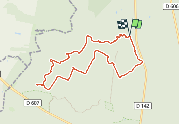

Length
9.7 km

Max alt
152 m

Uphill gradient
126 m
Km-Effort
11.4 km

Min alt
88 m

Downhill gradient
126 m
Boucle
Yes
Creation date :
2024-06-12 12:06:21.624
Updated on :
2024-06-12 15:04:47.384
2h57
Difficulty : Very easy

FREE GPS app for hiking
 SityTrail
IGN / Geographical institutes
SityTrail Plus
The world is yours!
About
Trail Walking of 9.7 km to be discovered at Ile-de-France, Seine-et-Marne, Fontainebleau. This trail is proposed by Isidore Hernandez 2.
Positioning
Country:
France
Region :
Ile-de-France
Department/Province :
Seine-et-Marne
Municipality :
Fontainebleau
Location:
Unknown
Start:(Dec)
Start:(UTM)
475280 ; 5367851 (31U) N.
Comments