


Mont Guillaume depuis le belvédère de la Para

orsel
User GUIDE
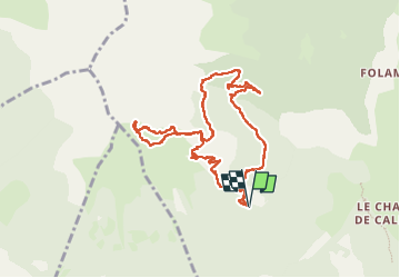

Length
9.9 km

Max alt
2529 m

Uphill gradient
894 m
Km-Effort
22 km

Min alt
1692 m

Downhill gradient
891 m
Boucle
Yes
Creation date :
2024-06-12 07:05:28.453
Updated on :
2024-06-12 15:53:42.536
6h46
Difficulty : Medium

FREE GPS app for hiking
 SityTrail
IGN / Geographical institutes
SityTrail Plus
The world is yours!
About
Trail Walking of 9.9 km to be discovered at Provence-Alpes-Côte d'Azur, Hautes-Alpes, Embrun. This trail is proposed by orsel.
Positioning
Country:
France
Region :
Provence-Alpes-Côte d'Azur
Department/Province :
Hautes-Alpes
Municipality :
Embrun
Location:
Unknown
Start:(Dec)
Start:(UTM)
297958 ; 4939024 (32T) N.
Comments