


rotonde niolon

mthomas30
User

Length
9.6 km

Max alt
73 m

Uphill gradient
320 m
Km-Effort
13.8 km

Min alt
1 m

Downhill gradient
304 m
Boucle
No
Creation date :
2024-05-26 07:16:28.531
Updated on :
2024-06-12 19:14:29.953
3h03
Difficulty : Medium

FREE GPS app for hiking
 SityTrail
IGN / Geographical institutes
SityTrail Plus
The world is yours!
About
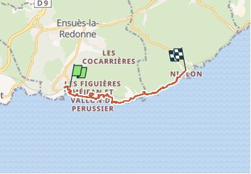
Trail Walking of 9.6 km to be discovered at Provence-Alpes-Côte d'Azur, Bouches-du-Rhône, Ensuès-la-Redonne. This trail is proposed by mthomas30.
Positioning
Country:
France
Region :
Provence-Alpes-Côte d'Azur
Department/Province :
Bouches-du-Rhône
Municipality :
Ensuès-la-Redonne
Location:
Unknown
Start:(Dec)
Start:(UTM)
678327 ; 4800306 (31T) N.
Comments