


La fruitière

CSMSRANDOS
User
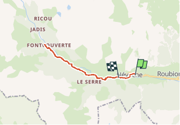

Length
13 km

Max alt
1879 m

Uphill gradient
362 m
Km-Effort
17.8 km

Min alt
1594 m

Downhill gradient
331 m
Boucle
No
Creation date :
2024-06-12 07:23:09.72
Updated on :
2024-06-12 19:54:19.257
3h30
Difficulty : Medium

FREE GPS app for hiking
 SityTrail
IGN / Geographical institutes
SityTrail Plus
The world is yours!
About
Trail Walking of 13 km to be discovered at Provence-Alpes-Côte d'Azur, Hautes-Alpes, Névache. This trail is proposed by CSMSRANDOS.
Description
le long de la clarée
Positioning
Country:
France
Region :
Provence-Alpes-Côte d'Azur
Department/Province :
Hautes-Alpes
Municipality :
Névache
Location:
Unknown
Start:(Dec)
Start:(UTM)
311530 ; 4987815 (32T) N.
Comments