


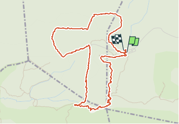
BONNIEUX 2024.06.06 - Forêt de cèdres

rando30129
User

Length
6.4 km

Max alt
721 m

Uphill gradient
155 m
Km-Effort
8.5 km

Min alt
627 m

Downhill gradient
156 m
Boucle
Yes
Creation date :
2024-06-06 07:56:42.0
Updated on :
2024-06-16 11:50:19.69
2h11
Difficulty : Medium

FREE GPS app for hiking
 SityTrail
IGN / Geographical institutes
SityTrail Plus
The world is yours!
About
Trail Walking of 6.4 km to be discovered at Provence-Alpes-Côte d'Azur, Vaucluse, Bonnieux. This trail is proposed by rando30129.
Positioning
Country:
France
Region :
Provence-Alpes-Côte d'Azur
Department/Province :
Vaucluse
Municipality :
Bonnieux
Location:
Unknown
Start:(Dec)
Start:(UTM)
682902 ; 4852196 (31T) N.
Comments