


ceceles

tobia
User
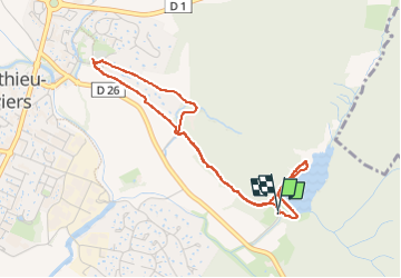

Length
4.4 km

Max alt
138 m

Uphill gradient
63 m
Km-Effort
5.3 km

Min alt
103 m

Downhill gradient
60 m
Boucle
Yes
Creation date :
2024-06-13 07:31:40.12
Updated on :
2024-06-13 09:35:13.989
2h02
Difficulty : Easy

FREE GPS app for hiking
 SityTrail
IGN / Geographical institutes
SityTrail Plus
The world is yours!
About
Trail Walking of 4.4 km to be discovered at Occitania, Hérault, Saint-Mathieu-de-Tréviers. This trail is proposed by tobia.
Positioning
Country:
France
Region :
Occitania
Department/Province :
Hérault
Municipality :
Saint-Mathieu-de-Tréviers
Location:
Unknown
Start:(Dec)
Start:(UTM)
571402 ; 4845879 (31T) N.
Comments