


dg il

bernir
User
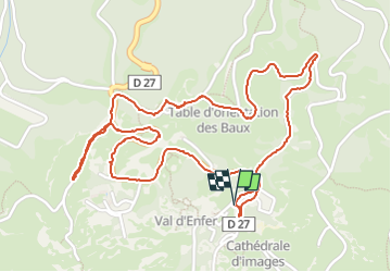

Length
3.4 km

Max alt
264 m

Uphill gradient
88 m
Km-Effort
4.6 km

Min alt
174 m

Downhill gradient
86 m
Boucle
Yes
Creation date :
2024-06-13 09:52:22.439
Updated on :
2024-06-13 15:16:24.967
5h23
Difficulty : Easy

FREE GPS app for hiking
 SityTrail
IGN / Geographical institutes
SityTrail Plus
The world is yours!
About
Trail Walking of 3.4 km to be discovered at Provence-Alpes-Côte d'Azur, Bouches-du-Rhône, Les Baux-de-Provence. This trail is proposed by bernir.
Positioning
Country:
France
Region :
Provence-Alpes-Côte d'Azur
Department/Province :
Bouches-du-Rhône
Municipality :
Les Baux-de-Provence
Location:
Unknown
Start:(Dec)
Start:(UTM)
644619 ; 4845631 (31T) N.
Comments