


chantelinotte

bymarc26
User
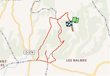

Length
10 km

Max alt
279 m

Uphill gradient
173 m
Km-Effort
12.3 km

Min alt
159 m

Downhill gradient
179 m
Boucle
Yes
Creation date :
2024-06-13 13:15:30.145
Updated on :
2024-06-13 15:39:01.355
2h14
Difficulty : Easy

FREE GPS app for hiking
 SityTrail
IGN / Geographical institutes
SityTrail Plus
The world is yours!
About
Trail Walking of 10 km to be discovered at Auvergne-Rhône-Alpes, Drôme, Romans-sur-Isère. This trail is proposed by bymarc26.
Positioning
Country:
France
Region :
Auvergne-Rhône-Alpes
Department/Province :
Drôme
Municipality :
Romans-sur-Isère
Location:
Unknown
Start:(Dec)
Start:(UTM)
658110 ; 4993175 (31T) N.
Comments