


GR057_Escapardenne-Parcours-principal_2022-05-23

collignpn
User GUIDE
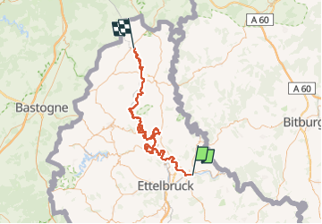

Length
87 km

Max alt
507 m

Uphill gradient
3424 m
Km-Effort
132 km

Min alt
185 m

Downhill gradient
3191 m
Boucle
No
Creation date :
2024-06-14 13:01:57.299
Updated on :
2024-06-14 13:01:57.299
0m
Difficulty : Medium

FREE GPS app for hiking
 SityTrail
IGN / Geographical institutes
SityTrail Plus
The world is yours!
About
Trail Nordic walking of 87 km to be discovered at Unknown, Canton Diekirch, Bettendorf. This trail is proposed by collignpn.
Positioning
Country:
Luxembourg
Region :
Unknown
Department/Province :
Canton Diekirch
Municipality :
Bettendorf
Location:
Unknown
Start:(Dec)
Start:(UTM)
297467 ; 5527830 (32U) N.
Comments