


SityTrail - RS-TTes Aures-1

raymondfn
User
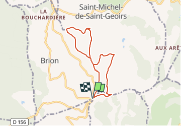

Length
6.7 km

Max alt
692 m

Uphill gradient
218 m
Km-Effort
9.6 km

Min alt
525 m

Downhill gradient
218 m
Boucle
Yes
Creation date :
2024-06-15 08:19:14.71
Updated on :
2024-06-15 08:39:34.837
2h11
Difficulty : Medium

FREE GPS app for hiking
 SityTrail
IGN / Geographical institutes
SityTrail Plus
The world is yours!
About
Trail Walking of 6.7 km to be discovered at Auvergne-Rhône-Alpes, Isère, Chasselay. This trail is proposed by raymondfn.
Positioning
Country:
France
Region :
Auvergne-Rhône-Alpes
Department/Province :
Isère
Municipality :
Chasselay
Location:
Unknown
Start:(Dec)
Start:(UTM)
684485 ; 5017201 (31T) N.
Comments