


Essai 3

patrickbeyrath
User
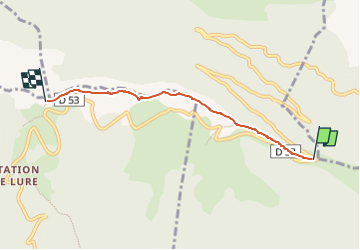

Length
4.1 km

Max alt
1823 m

Uphill gradient
263 m
Km-Effort
7.2 km

Min alt
1595 m

Downhill gradient
140 m
Boucle
No
Creation date :
2024-06-16 05:33:30.0
Updated on :
2024-06-16 06:42:43.37
1h37
Difficulty : Medium

FREE GPS app for hiking
 SityTrail
IGN / Geographical institutes
SityTrail Plus
The world is yours!
About
Trail Walking of 4.1 km to be discovered at Provence-Alpes-Côte d'Azur, Alpes-de-Haute-Provence, Cruis. This trail is proposed by patrickbeyrath.
Positioning
Country:
France
Region :
Provence-Alpes-Côte d'Azur
Department/Province :
Alpes-de-Haute-Provence
Municipality :
Cruis
Location:
Unknown
Start:(Dec)
Start:(UTM)
726641 ; 4888577 (31T) N.
Comments