


varacieux

starco
User
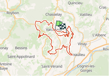

Length
44 km

Max alt
708 m

Uphill gradient
1330 m
Km-Effort
61 km

Min alt
287 m

Downhill gradient
1364 m
Boucle
No
Creation date :
2024-06-16 06:15:23.389
Updated on :
2024-06-16 09:58:20.413
3h42
Difficulty : Very difficult

FREE GPS app for hiking
 SityTrail
IGN / Geographical institutes
SityTrail Plus
The world is yours!
About
Trail Mountain bike of 44 km to be discovered at Auvergne-Rhône-Alpes, Isère, Varacieux. This trail is proposed by starco.
Description
rando vtt
Positioning
Country:
France
Region :
Auvergne-Rhône-Alpes
Department/Province :
Isère
Municipality :
Varacieux
Location:
Unknown
Start:(Dec)
Start:(UTM)
683645 ; 5011290 (31T) N.
Comments