


Lacs de Vens

GeorgesV.
User
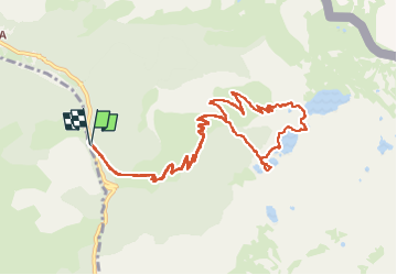

Length
13.4 km

Max alt
2413 m

Uphill gradient
890 m
Km-Effort
25 km

Min alt
1542 m

Downhill gradient
889 m
Boucle
Yes
Creation date :
2024-06-16 06:31:29.0
Updated on :
2024-06-16 13:40:54.059

FREE GPS app for hiking
 SityTrail
IGN / Geographical institutes
SityTrail Plus
The world is yours!
About
Trail of 13.4 km to be discovered at Provence-Alpes-Côte d'Azur, Maritime Alps, Saint-Étienne-de-Tinée. This trail is proposed by GeorgesV..
Photos


Positioning
Country:
France
Region :
Provence-Alpes-Côte d'Azur
Department/Province :
Maritime Alps
Municipality :
Saint-Étienne-de-Tinée
Location:
Unknown
Start:(Dec)
Start:(UTM)
332598 ; 4908468 (32T) N.
Comments