


Saint Vallières bois d amont 06

papajp
User
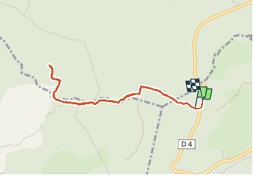

Length
4.2 km

Max alt
689 m

Uphill gradient
118 m
Km-Effort
5.7 km

Min alt
572 m

Downhill gradient
111 m
Boucle
Yes
Creation date :
2024-06-16 13:30:20.0
Updated on :
2024-06-16 14:52:47.075

FREE GPS app for hiking
 SityTrail
IGN / Geographical institutes
SityTrail Plus
The world is yours!
About
Trail of 4.2 km to be discovered at Provence-Alpes-Côte d'Azur, Maritime Alps, Spéracèdes. This trail is proposed by papajp.
Positioning
Country:
France
Region :
Provence-Alpes-Côte d'Azur
Department/Province :
Maritime Alps
Municipality :
Spéracèdes
Location:
Unknown
Start:(Dec)
Start:(UTM)
326931 ; 4836413 (32T) N.
Comments