


Mont Ours

Renefrt
User
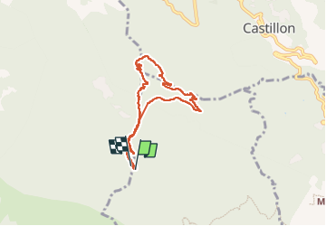

Length
7.6 km

Max alt
1229 m

Uphill gradient
535 m
Km-Effort
14.8 km

Min alt
726 m

Downhill gradient
531 m
Boucle
Yes
Creation date :
2024-06-13 07:35:49.882
Updated on :
2024-06-17 06:31:57.836
6h08
Difficulty : Medium

FREE GPS app for hiking
 SityTrail
IGN / Geographical institutes
SityTrail Plus
The world is yours!
About
Trail Walking of 7.6 km to be discovered at Provence-Alpes-Côte d'Azur, Maritime Alps, Sainte-Agnès. This trail is proposed by Renefrt.
Photos


Positioning
Country:
France
Region :
Provence-Alpes-Côte d'Azur
Department/Province :
Maritime Alps
Municipality :
Sainte-Agnès
Location:
Unknown
Start:(Dec)
Start:(UTM)
375095 ; 4852344 (32T) N.
Comments