


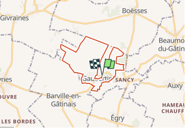
Visite de Gaubertin

mathis01
User

Length
14.7 km

Max alt
117 m

Uphill gradient
65 m
Km-Effort
15.5 km

Min alt
97 m

Downhill gradient
65 m
Boucle
Yes
Creation date :
2024-06-17 16:21:49.086
Updated on :
2025-02-17 09:53:41.553
3h31
Difficulty : Easy

FREE GPS app for hiking
 SityTrail
IGN / Geographical institutes
SityTrail Plus
The world is yours!
About
Trail On foot of 14.7 km to be discovered at Centre-Loire Valley, Loiret, Gaubertin. This trail is proposed by mathis01.
Positioning
Country:
France
Region :
Centre-Loire Valley
Department/Province :
Loiret
Municipality :
Gaubertin
Location:
Unknown
Start:(Dec)
Start:(UTM)
457366 ; 5330068 (31U) N.
Comments