


FFRandonnée Indre rocher de la fileuse

houbart
User
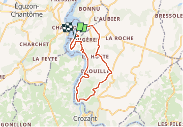

Length
13.6 km

Max alt
295 m

Uphill gradient
287 m
Km-Effort
17.4 km

Min alt
200 m

Downhill gradient
284 m
Boucle
Yes
Creation date :
2024-06-17 18:43:38.572
Updated on :
2024-06-17 18:48:52.876
3h57
Difficulty : Difficult

FREE GPS app for hiking
 SityTrail
IGN / Geographical institutes
SityTrail Plus
The world is yours!
About
Trail Walking of 13.6 km to be discovered at Centre-Loire Valley, Indre, Saint-Plantaire. This trail is proposed by houbart.
Positioning
Country:
France
Region :
Centre-Loire Valley
Department/Province :
Indre
Municipality :
Saint-Plantaire
Location:
Unknown
Start:(Dec)
Start:(UTM)
393573 ; 5142623 (31T) N.
Comments