


provins avec souterrains

olivieraron
User
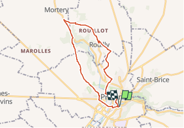

Length
13 km

Max alt
155 m

Uphill gradient
177 m
Km-Effort
15.3 km

Min alt
86 m

Downhill gradient
177 m
Boucle
Yes
Creation date :
2024-06-18 05:48:30.859
Updated on :
2024-06-18 05:49:02.17
3h29
Difficulty : Difficult

FREE GPS app for hiking
 SityTrail
IGN / Geographical institutes
SityTrail Plus
The world is yours!
About
Trail Walking of 13 km to be discovered at Ile-de-France, Seine-et-Marne, Provins. This trail is proposed by olivieraron.
Positioning
Country:
France
Region :
Ile-de-France
Department/Province :
Seine-et-Marne
Municipality :
Provins
Location:
Unknown
Start:(Dec)
Start:(UTM)
522371 ; 5378129 (31U) N.
Comments