


Étang St Nicolas

bernardjanin
User
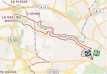

Length
10.4 km

Max alt
47 m

Uphill gradient
117 m
Km-Effort
11.9 km

Min alt
22 m

Downhill gradient
118 m
Boucle
Yes
Creation date :
2024-06-18 07:19:30.659
Updated on :
2024-06-18 10:34:23.7
3h12
Difficulty : Medium

FREE GPS app for hiking
 SityTrail
IGN / Geographical institutes
SityTrail Plus
The world is yours!
About
Trail Walking of 10.4 km to be discovered at Pays de la Loire, Maine-et-Loire, Angers. This trail is proposed by bernardjanin.
Positioning
Country:
France
Region :
Pays de la Loire
Department/Province :
Maine-et-Loire
Municipality :
Angers
Location:
Unknown
Start:(Dec)
Start:(UTM)
682607 ; 5260685 (30T) N.
Comments