


2024-06-18_22h29m42_toulouse_alti

zazibelle
User
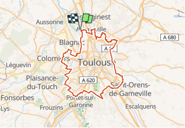

Length
71 km

Max alt
254 m

Uphill gradient
574 m
Km-Effort
79 km

Min alt
118 m

Downhill gradient
578 m
Boucle
Yes
Creation date :
2024-06-18 20:29:42.449
Updated on :
2024-06-19 11:25:19.703
17h53
Difficulty : Very difficult

FREE GPS app for hiking
 SityTrail
IGN / Geographical institutes
SityTrail Plus
The world is yours!
About
Trail Walking of 71 km to be discovered at Occitania, Haute-Garonne, Fenouillet. This trail is proposed by zazibelle.
Positioning
Country:
France
Region :
Occitania
Department/Province :
Haute-Garonne
Municipality :
Fenouillet
Location:
Unknown
Start:(Dec)
Start:(UTM)
371005 ; 4836096 (31T) N.
Comments