


villard saint christophe

ascq
User
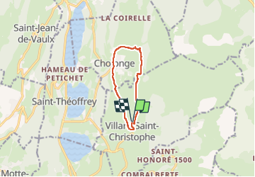

Length
8.7 km

Max alt
1377 m

Uphill gradient
370 m
Km-Effort
13.6 km

Min alt
1053 m

Downhill gradient
377 m
Boucle
Yes
Creation date :
2024-06-19 06:07:41.526
Updated on :
2024-06-19 08:33:10.36
2h25
Difficulty : Medium

FREE GPS app for hiking
 SityTrail
IGN / Geographical institutes
SityTrail Plus
The world is yours!
About
Trail Walking of 8.7 km to be discovered at Auvergne-Rhône-Alpes, Isère, Villard-Saint-Christophe. This trail is proposed by ascq.
Positioning
Country:
France
Region :
Auvergne-Rhône-Alpes
Department/Province :
Isère
Municipality :
Villard-Saint-Christophe
Location:
Unknown
Start:(Dec)
Start:(UTM)
721184 ; 4984788 (31T) N.
Comments