Chemin des oliviers

michelpaulin
User
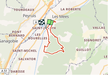

Length
11.3 km

Max alt
691 m

Uphill gradient
329 m
Km-Effort
15.7 km

Min alt
422 m

Downhill gradient
329 m
Boucle
Yes
Creation date :
2024-06-19 08:09:57.0
Updated on :
2024-06-19 14:00:48.34

FREE GPS app for hiking
 SityTrail
IGN / Geographical institutes
SityTrail Plus
The world is yours!
About
Trail of 11.3 km to be discovered at Provence-Alpes-Côte d'Azur, Alpes-de-Haute-Provence, Les Mées. This trail is proposed by michelpaulin.
Positioning
Country:
France
Region :
Provence-Alpes-Côte d'Azur
Department/Province :
Alpes-de-Haute-Provence
Municipality :
Les Mées
Location:
Unknown
Start:(Dec)
Start:(UTM)
737251 ; 4878247 (31T) N.
Comments