


PN2024 J2

Airelle
User
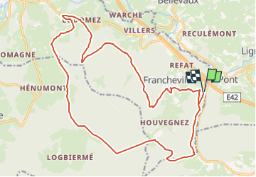

Length
22 km

Max alt
579 m

Uphill gradient
536 m
Km-Effort
29 km

Min alt
365 m

Downhill gradient
535 m
Boucle
Yes
Creation date :
2024-06-19 19:38:32.68
Updated on :
2024-06-19 19:51:57.984
6h37
Difficulty : Medium

FREE GPS app for hiking
 SityTrail
IGN / Geographical institutes
SityTrail Plus
The world is yours!
About
Trail On foot of 22 km to be discovered at Wallonia, Liège, Stavelot. This trail is proposed by Airelle.
Positioning
Country:
Belgium
Region :
Wallonia
Department/Province :
Liège
Municipality :
Stavelot
Location:
Unknown
Start:(Dec)
Start:(UTM)
288475 ; 5583218 (32U) N.
Comments