


rando n°3

dudu79
User
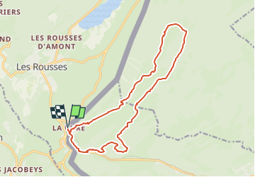

Length
16.9 km

Max alt
1557 m

Uphill gradient
656 m
Km-Effort
26 km

Min alt
1155 m

Downhill gradient
656 m
Boucle
Yes
Creation date :
2024-06-20 06:43:25.399
Updated on :
2024-06-20 07:08:23.852
5h49
Difficulty : Very difficult

FREE GPS app for hiking
 SityTrail
IGN / Geographical institutes
SityTrail Plus
The world is yours!
About
Trail Walking of 16.9 km to be discovered at Vaud, District de Nyon, Saint-Cergue. This trail is proposed by dudu79.
Positioning
Country:
Switzerland
Region :
Vaud
Department/Province :
District de Nyon
Municipality :
Saint-Cergue
Location:
Unknown
Start:(Dec)
Start:(UTM)
275296 ; 5149886 (32T) N.
Comments