


CC_Piemont_BD_09_Mirepoix_Vals_20240620

patrickdanilo
User
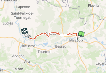

Length
13.7 km

Max alt
434 m

Uphill gradient
331 m
Km-Effort
18.2 km

Min alt
267 m

Downhill gradient
370 m
Boucle
No
Creation date :
2024-06-20 06:24:12.243
Updated on :
2024-09-18 16:41:45.855
4h48
Difficulty : Medium

FREE GPS app for hiking
 SityTrail
IGN / Geographical institutes
SityTrail Plus
The world is yours!
About
Trail Walking of 13.7 km to be discovered at Occitania, Ariège, Mirepoix. This trail is proposed by patrickdanilo.
Description
Randonnée Marche de 13,7 km à découvrir à Occitanie, Ariège, Mirepoix. Cette randonnée est proposée par patrickdanilo.
Photos


Positioning
Country:
France
Region :
Occitania
Department/Province :
Ariège
Municipality :
Mirepoix
Location:
Unknown
Start:(Dec)
Start:(UTM)
408530 ; 4771238 (31T) N.
Comments