


Col de l'Eychauda

cron
User
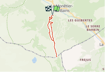

Length
10.5 km

Max alt
2429 m

Uphill gradient
890 m
Km-Effort
22 km

Min alt
1547 m

Downhill gradient
890 m
Boucle
Yes
Creation date :
2024-06-20 20:05:28.246
Updated on :
2024-06-20 20:06:00.098
5h05
Difficulty : Difficult

FREE GPS app for hiking
 SityTrail
IGN / Geographical institutes
SityTrail Plus
The world is yours!
About
Trail Walking of 10.5 km to be discovered at Provence-Alpes-Côte d'Azur, Hautes-Alpes, Le Monêtier-les-Bains. This trail is proposed by cron.
Positioning
Country:
France
Region :
Provence-Alpes-Côte d'Azur
Department/Province :
Hautes-Alpes
Municipality :
Le Monêtier-les-Bains
Location:
Unknown
Start:(Dec)
Start:(UTM)
302798 ; 4982663 (32T) N.
Comments