


CC_Piemont_BE_10_Vals_Pamiers_20240621

patrickdanilo
User
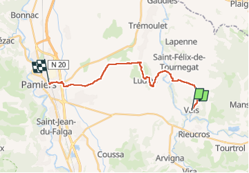

Length
20 km

Max alt
390 m

Uphill gradient
305 m
Km-Effort
24 km

Min alt
255 m

Downhill gradient
279 m
Boucle
No
Creation date :
2024-06-21 04:51:21.723
Updated on :
2024-07-08 10:19:21.57
4h35
Difficulty : Easy

FREE GPS app for hiking
 SityTrail
IGN / Geographical institutes
SityTrail Plus
The world is yours!
About
Trail Walking of 20 km to be discovered at Occitania, Ariège, Vals. This trail is proposed by patrickdanilo.
Description
Randonnée Marche de 20 km à découvrir à Occitanie, Ariège, Vals. Cette randonnée est proposée par patrickdanilo.
Photos


Positioning
Country:
France
Region :
Occitania
Department/Province :
Ariège
Municipality :
Vals
Location:
Unknown
Start:(Dec)
Start:(UTM)
399147 ; 4772198 (31T) N.
Comments