


20240621 Pouzac

Childebert
User
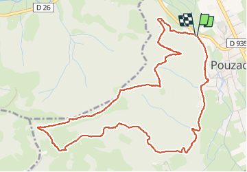

Length
6.8 km

Max alt
753 m

Uphill gradient
247 m
Km-Effort
10.1 km

Min alt
505 m

Downhill gradient
248 m
Boucle
Yes
Creation date :
2024-06-21 08:43:06.465
Updated on :
2024-06-21 11:47:26.093
3h02
Difficulty : Medium

FREE GPS app for hiking
 SityTrail
IGN / Geographical institutes
SityTrail Plus
The world is yours!
About
Trail Walking of 6.8 km to be discovered at Occitania, Hautespyrenees, Pouzac. This trail is proposed by Childebert.
Photos


Positioning
Country:
France
Region :
Occitania
Department/Province :
Hautespyrenees
Municipality :
Pouzac
Location:
Unknown
Start:(Dec)
Start:(UTM)
266436 ; 4774536 (31T) N.
Comments