


Pierre Arnoux

pblois
User
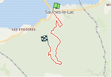

Length
5.4 km

Max alt
1349 m

Uphill gradient
541 m
Km-Effort
10.9 km

Min alt
797 m

Downhill gradient
42 m
Boucle
No
Creation date :
2024-06-21 13:47:47.111
Updated on :
2024-06-21 14:55:32.781
2h28
Difficulty : Medium

FREE GPS app for hiking
 SityTrail
IGN / Geographical institutes
SityTrail Plus
The world is yours!
About
Trail Walking of 5.4 km to be discovered at Provence-Alpes-Côte d'Azur, Hautes-Alpes, Savines-le-Lac. This trail is proposed by pblois.
Description
Chemin pédestre pour se rendre à la fête de fin d'année du club
Positioning
Country:
France
Region :
Provence-Alpes-Côte d'Azur
Department/Province :
Hautes-Alpes
Municipality :
Savines-le-Lac
Location:
Unknown
Start:(Dec)
Start:(UTM)
293479 ; 4933528 (32T) N.
Comments